Cedros – Alpamayo & Santa Cruz Trek – 11 Days

Code: CSCT4D3N
11 DAYS - 10 NIGHTS
Category:
  • Valle de Santa Cruz (1)-convertido-a-1920x1356
  • Valle de Santa cruz
  • Taulliraju 5 (1)-convertido-a-1920×1356
  • Taulliraju_peak-peru-inkaland-treks (1)-convertido-a-1920×1356

The Cedros–Alpamayo & Santa Cruz Trek – 11 Days is the ultimate adventure for hikers seeking to experience the best of Peru’s Cordillera Blanca.

This extended route combines two of the most spectacular trails — Cedros–Alpamayo Circuit and the classic Santa Cruz Trek — creating a continuous expedition through dramatic valleys, turquoise lakes, and the iconic pyramid-shaped Alpamayo (5,947 m / 19,511 ft), known as “The Most Beautiful Mountain in the World.”

A challenging but rewarding high-altitude journey — exclusively operated by Inkaland Treks for trekkers who want the most complete Cordillera Blanca experience.

This 11-day trek traverses remote valleys, glacial lakes, and passes over 4,800 meters, connecting the Cedros Valley with the legendary Santa Cruz Valley.
You’ll explore isolated Andean communities, panoramic passes such as Osoruri (4,860 m) and Punta Unión (4,750 m), and camp beneath Alpamayo’s towering face.

The circuit offers a perfect balance of solitude, scenery, and cultural immersion — ideal for well-acclimatized trekkers with prior hiking experience.

Quick Facts Huayhuash Trek – Trapecio Pass

  • Location: Cordillera Blanca, Huascarán National Park
  • Duration: 11 days / 10 nights
  • Distance: ~120 km / 75 mi total
  • Highest Point: 4,860 m / 15,944 ft (Osoruri Pass)
  • Difficulty: Moderate to Challenging
  • Best Season: May – October (dry season)
  • Start / End: Hualcayán → Cashapampa → Huaraz
  • Group Size: Small groups (max 8) or private treks

👉 Recommended for trekkers with good physical condition and prior acclimatization (3–4 days in Huaraz).

Highlights Huayhuash Trek – Trapecio Pass

  • Combine two legendary treks: Cedros–Alpamayo & Santa Cruz in one route
  • Admire the world-famous Alpamayo (5,947 m) — “The Most Beautiful Mountain in the World”
  • Cross six high passes over 4,500 m including Osoruri, Vientunan, Gara Gara, Yanacon, Pucaraju, and Punta Unión
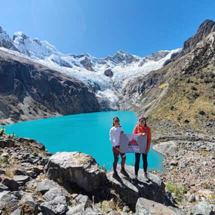
  • Explore turquoise glacial lakes: Cullicocha, Arhuaycocha, Ichiccocha, Jatuncocha
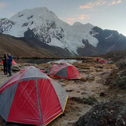
  • Camp in remote valleys surrounded by Andean peaks
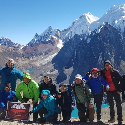
  • Guided by professional English-speaking mountain guides with full Inkaland Treks expedition support

Itinerary at a Glance

Day Route Distance Max Elevation Hiking Time Highlights
1 Huaraz → Hualcayán → Huishcash 8 km / 5 mi 4,200 m / 13,779 ft 5–6 h Begin trek, first ascent
2 Huishcash → Osoruri 10 km / 6.2 mi 4,860 m / 15,944 ft 6–7 h Cross Osoruri Pass & lakes
3 Osoruri → Vientunan Pass → Jancarurish 11 km / 6.8 mi 4,770 m / 15,650 ft 6–7 h First views of Alpamayo
4 Jancarurish → Alpamayo Viewpoint → Jancarurish 5 km / 3.1 mi 4,450 m / 14,600 ft 3 h Rest day & viewpoint
5 Jancarurish → Gara Gara Pass → Mesapampa → Huillca 14 km / 8.7 mi 4,830 m / 15,846 ft 7 h Mountain passes & valleys
6 Huillca → Yanacón Pass → Jancapampa 13 km / 8.1 mi 4,600 m / 15,092 ft 7 h Descent into lush valley
7 Jancapampa → Tupa Tupa Pass → Quishuar 12 km / 7.4 mi 4,400 m / 14,436 ft 7 h Village encounters & alpine views
8 Quishuar → Pucaraju Pass → Tuctu 13 km / 8.1 mi 4,650 m / 15,256 ft 7 h Views of Huascarán & Chacraraju
9 Tuctu → Punta Unión Pass → Taullipampa 11 km / 6.8 mi 4,750 m / 15,584 ft 8 h Cross the legendary pass
10 Taullipampa → Alpamayo Base Camp → Arhuaycocha → Llamacorral 20 km / 12.4 mi 4,420 m / 14,501 ft 9 h Visit Alpamayo & turquoise lakes
11 Llamacorral → Cashapampa → Huaraz 10 km / 6.2 mi + 95 km drive 2,900 m / 9,514 ft 4 h + 3 h drive Final descent & return

All distances and times are approximate and may vary depending on weather and pace.

1

Day 1 – Huaraz → Hualcayán → Huishcash

Max Altitude: 4,200 m / 13,779 ft | Distance: 8 km / 5 mi | Hiking Time: 5–6 hours

Morning drive from Huaraz (3,050 m) to the village of Hualcayán (3,140 m). Begin ascending in zigzag along an ancient trail with views of the Cordillera Negra.
Overnight at Huishcash Camp (4,200 m).

2

Day 2 – Huishcash → Osoruri Pass → Osoruri Camp

Max Altitude: 4,860 m / 15,944 ft | Distance: 10 km / 6.2 mi | Hiking Time: 6–7 hours

Gradual ascent to Osoruri Pass (4,860 m) with panoramic views of Cullicocha, Azulcocha, and Yanacocha Lakes. Continue along alpine ridges to camp near Osoruri (4,550 m).
Overnight at Osoruri Camp.

3

Day 3 – Osoruri → Vientunan Pass → Jancarurish (Alpamayo Valley)

Max Altitude: 4,770 m / 15,650 ft | Distance: 11 km / 6.8 mi | Hiking Time: 6–7 hours

Cross Vientunan Pass and descend into the Cedros Valley, following scenic ridges to reach the Alpamayo Valley, where you’ll see the stunning northwest face of Alpamayo (5,947 m).
Overnight at Jancarurish Camp (3,800 m).

4

Day 4 – Jancarurish → Alpamayo Viewpoint → Jancarurish

Max Altitude: 4,450 m / 14,600 ft | Distance: 5 km / 3.1 mi | Hiking Time: 3 hours**

Optional short hike to the Alpamayo Viewpoint, where the famous photo of the mountain’s pyramid-shaped face was taken. Afternoon rest at camp.
Overnight at Jancarurish Camp.

5

Day 5 – Jancarurish → Gara Gara & Mesapampa Passes → Huillca

Max Altitude: 4,830 m / 15,846 ft | Distance: 14 km / 8.7 mi | Hiking Time: 7 hours

Climb two passes — Gara Gara (4,830 m) and Mesapampa (4,500 m) — for magnificent views of the Blanca peaks before descending into Huillca Valley (4,300 m).
Overnight at Huillca Camp.

6

Day 6 – Huillca → Yanacón Pass → Jancapampa

Max Altitude: 4,600 m / 15,092 ft | Distance: 13 km / 8.1 mi | Hiking Time: 7 hours

A scenic day through Yana Queñua Valley, crossing the Yanacón Pass (4,600 m) with spectacular landscapes before descending into the lush valley of Jancapampa (3,600 m), home to Andean farming families.
Overnight at Jancapampa Camp.

7

Day 7 – Jancapampa → Tupa Tupa Pass → Quishuar

Max Altitude: 4,400 m / 14,436 ft | Distance: 12 km / 7.4 mi | Hiking Time: 7 hours

Hike past Pishgopampa and ascend through Tingopampa Valley to cross Tupa Tupa Pass (4,400 m).
Descend to Quishuar Camp (3,800 m) with views of high peaks and the deep green valleys below.
Overnight at Quishuar Camp.

8

Day 8 – Quishuar → Pucaraju Pass → Tuctu

Max Altitude: 4,650 m / 15,256 ft | Distance: 13 km / 8.1 mi | Hiking Time: 7 hours

Climb gradually to Pucaraju Pass (4,650 m) for panoramic views of Huascarán, Chopicalqui, Chacraraju, and Taulliraju.
Descend into the scenic Huaripampa Valley, surrounded by forests of quenuales.
Overnight at Tuctu Camp (4,200 m).

9

Day 9 – Tuctu → Punta Unión Pass → Taullipampa

Max Altitude: 4,750 m / 15,584 ft | Distance: 11 km / 6.8 mi | Hiking Time: 8 hours

Ascend to the famous Punta Unión Pass, one of the most beautiful viewpoints of the entire Cordillera Blanca.
Descend into Taullipampa (4,250 m), surrounded by the massive peaks of Taulliraju and Artesonraju.
Overnight at Taullipampa Camp.

10

Day 10 – Taullipampa → Alpamayo Base Camp → Arhuaycocha Lake → Llamacorral

Max Altitude: 4,420 m / 14,501 ft | Distance: 20 km / 12.4 mi | Hiking Time: 9 hours

A long but rewarding day visiting Alpamayo Base Camp and Arhuaycocha Lake (4,420 m), one of the most photogenic spots in the Andes.
Continue down the Santa Cruz Valley to Llamacorral (3,760 m).
Overnight at Llamacorral Camp.

11

Day 11 – Llamacorral → Cashapampa → Huaraz

Max Altitude: 2,900 m / 9,514 ft | Distance: 10 km / 6.2 mi + 95 km drive | Hiking Time: 4 hours + 3 hours drive

Descend through the Santa Cruz Canyon, surrounded by waterfalls and lush vegetation, until reaching Cashapampa (2,900 m).
Private transport will take you back to Huaraz.
Arrival by mid-afternoon.

Departure

Departures 2026 – Join a Group or Go Private

Month Dates Status
June Start 10 – 20 June ✅ Open
July Start 15 – 25 July ✅ Open
August – September Custom departures available 🏕 On request

📩 Contact us to join a confirmed group or open a private departure on your preferred dates.

FAQ

Good to Know / Practical Information

Cedros – Alpamayo & Santa Cruz Trek – 11 Days

Is this trek difficult?
Moderate to challenging — it requires good physical condition and previous trekking experience due to its altitude and duration.

When is the best time to go?
Between May and October, during Peru’s dry season.

Do we see Alpamayo closely?
Yes — the trek reaches Jancarurish Valley, offering the best panoramic view of Alpamayo’s pyramid face.

Is it a guided camping trek?
Yes — fully supported by professional guides, donkey teams, and camp staff.

INCLUSION

Cedros – Alpamayo & Santa Cruz Trek

✅ Included

  • Professional English/Spanish-speaking mountain guide
  • Private transport Huaraz ↔ Hualcayán / Cashapampa ↔ Huaraz
  • Donkeys & muleteers (10 kg / 22 lb per participant)
  • Full camping service (4-season tents, mats, dining/kitchen/toilet tents)
  • All meals during trek (vegetarian/vegan/gluten-free options)
  • Entrance fees to Huascarán National Park
  • First Aid Kit & emergency oxygen

❌ Not Included

  • Hotels & meals in Huaraz (before/after trek)
  • Sleeping bag (available for rent)
  • Personal trekking gear
  • Travel insurance (mandatory)
  • Tips & personal expenses

🎒 What to Bring

  • Warm layered clothing & waterproof jacket
  • Trekking boots + camp shoes
  • Sleeping bag (–10 °C / 14 °F rating)
  • Hat, gloves, sunglasses, sunscreen, lip balm
  • Backpack (30–40 L)
  • Refillable water bottle (1.5–2 L)
  • Snacks & personal essentials

Price:$450

Book the tour

 Number ticket  × $450
Total = $450

Or

    Fill up the form below to tell us what you're looking for